
Every greenkeeper carries a mental map of the course: where the faulty valve is, which fairway floods or which knolls dry out first. The problem is that this map lives in one head and is lost when that person changes job. GIS maps for golf courses let you pour that knowledge into a shared system, with layers of information that can be consulted and updated.
A GIS, or geographic information system, is not magic and does not require a technical department. Let us look at six concrete maintenance uses, what data you need to get started and how to avoid the typical mistakes when launching a project of this kind.
What GIS Maps for Golf Courses Are and Why They Matter
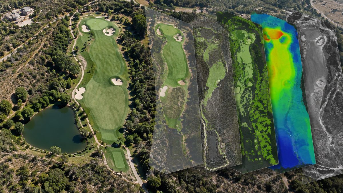
A GIS combines a base plan of the course with thematic layers. Each layer represents an element: holes, greens, fairways, bunkers, irrigation network, drainage, paths, trees, lakes or protected areas. You can switch them on and off, overlay them and attach data to each element.
What sets it apart from a PDF plan is that the information is tied to a real position. This way you can ask the map things like which sprinklers belong to a given sector, where the manholes of a drainage line are, or how many square metres each green has.
To get started, you usually only need:
- A recent orthophoto or aerial image of the course.
- The outline of the main elements on that base.
- A clear naming convention, so that everyone talks about the same thing.
That already gives you a single reference, useful for the crew, management and suppliers.
Use 1: Inventory of the Irrigation Network in GIS Maps for Golf Courses
The first use of GIS maps for golf courses, and almost always the most profitable, is to locate the irrigation network exactly. Sprinklers, valves, main pipes, valve boxes and quick-coupling points can be positioned and numbered. When there is a leak, knowing where the shut-off valve is saves hours of digging and lost water.
The map also makes it easier to:
- Plan repairs and renovations by sector.
- Detect areas with poor overlap or uneven coverage.
- Record the nozzle type and condition of each point.
And if the network changes, the map must change with it. An outdated layer is worse than none, because it gives false security. Define who updates what and when.

Use 2: Locate Drainage, Manholes and Buried Services
Among the uses of GIS maps for golf courses is the subsurface. Every course hides more infrastructure underground than people remember: drains, cables, pipes for other services, septic tanks or old conduits. When works, deep aeration or planting are carried out, knowing their layout avoids costly damage and accidents.
Document on the map:
- The approximate layout and known depths of drains and cabling.
- The position of manholes and inspection chambers.
- The areas where repairs or modifications took place.
When doing so, include the date and source of the information, because not all data is equally reliable. A precisely measured data point is worth more than a reference recalled from memory.
Use 3: Zone the Course for Daily Maintenance
Dividing the course into coherent zones helps distribute the work and analyse it. With GIS maps for golf courses you can draw polygons for greens, tee boxes, fairways, first cut, rough, bunkers and natural areas, and assign each one its service level, target cutting height and surface area.
This zoning is useful for:
- Calculating exact surface areas and estimating water, seed or fertiliser use.
- Organising mowing routes and staff shifts.
- Comparing hours and costs by zone type.
When the map and the work records use the same zone names, data cross-references effortlessly and analysis is much simpler.
Use 4: Tracking Problems and Treatments on the Plan
In GIS maps for golf courses, marking areas with dry spots, disease, compaction or pests reveals patterns that go unnoticed in a list. Perhaps the problems repeat in the shade of certain trees, next to a pipeline or in the highest-traffic areas.
You can also note where treatment has been applied and what was done at each point, always within the official treatment record. If a plant protection product has to be applied, the label, current regulations and the advice of an authorised technician will be followed; the map only helps to locate and to remember.
Overlaying problem layers with irrigation, soil or tree layers often gives very valuable clues about the underlying causes, not just the symptoms.
Use 5: Managing Bunkers, Trees and Landscape Features
Bunkers, trees, lakes and natural areas also benefit from GIS maps for golf courses and from a cartographic record. Each bunker can have its own record with surface area, sand type, drainage condition and repairs carried out. Each relevant tree, its species, condition and pending pruning.
This makes it possible to:
- Prioritise bunker renovations according to their real condition.
- Plan pruning and tree work with an overall view.
- Identify areas of ecological interest and protect them.
When an investment budget is prepared, having this data organised on the plan helps justify each item and defend it before the green committee with visible arguments.
Use 6: Communicate Better with the Crew, Management and Suppliers
A clear map is worth a thousand explanations, and GIS maps for golf courses prove it. When a contractor needs to know where to work, or when management wants to understand which areas are closed for works, a shared plan removes misunderstandings. With well-prepared layers, each person sees only what interests them.
Good practices to make it work:
- Start with a few layers and add more when they are really used.
- Appoint someone responsible for keeping the map up to date.
- Train the team to consult it and to report changes.
- Keep backups and dated versions.
GIS maps for golf courses do not replace the greenkeeper’s judgement: they amplify it. Their value depends on the data being alive and connected to the real tasks of the day-to-day work.
Further reading: Copernicus Programme. To understand what kinds of imagery and territorial data exist at European scale, you can consult the Copernicus programme.
Frequently asked questions
What do I need to get started with GIS maps for golf courses?
You only need an aerial image of the course, a mapping programme and the will to organise the data. Start by outlining the main elements and the irrigation network, use consistent names and assign one person to keep it updated. Then you can add layers according to the team's real needs.
Do GIS maps for golf courses replace traditional plans?
They complement them and, over time, usually replace them as the main reference. The advantage is that the information is georeferenced, can be consulted by layer and is easy to update. It is advisable to keep copies of the original plans and to check against the ground before making critical decisions.
Is it expensive to keep GIS maps for golf courses up to date?
The main cost is time: capturing the data at the start and reviewing it when something changes on the course. If the team builds updating into the routine, after each job or repair, the effort is small. What is costly is keeping an outdated map that gives wrong information.
Keep reading
- drones on golf courses Drones on golf courses: 6 valuable applications
- NDVI on turf to detect stress NDVI for Turf: 5 Uses to Detect Stress
- soil moisture sensors Soil Moisture Sensors: 6 Key Uses in Golf